Hexacopter to change industry
Northern Survey Supply (NSS) owner Marty Warkentin sees the newly launched Aibot X6 V2 Hexacopter from Aibotix GmbH as a game-changer for the surveying industry.
Northern Survey Supply is the exclusive Canadian distributor for the vertical take-off and landing, unmanned aerial vehicle, which will have a variety of uses and applications in mining and other industries.
Warkentin and his team from NSS saw a demonstration of the Aibot X6 V2 at a Leica conference in 2013 and were sold.
“We saw the demonstration and right away we had to buy one,” Warkentin said. “We knew we had to get into this industry. At the moment, we are the sole distributor in Canada. Our job is to sell units to service providers such as engineering companies, environmental firms, surveyors and mining companies.
In the interim, we are providing rentals of the vehicle. To rent the unit, a customer calls and indicates what has to be done. We discuss the best method and supply the unit along with an operator to the customer. We do not want to be viewed as a service provider. We want to sell to service providers. To do this, we need to have seminars and do presentations to promote awareness of the product.”
Carbon fibre
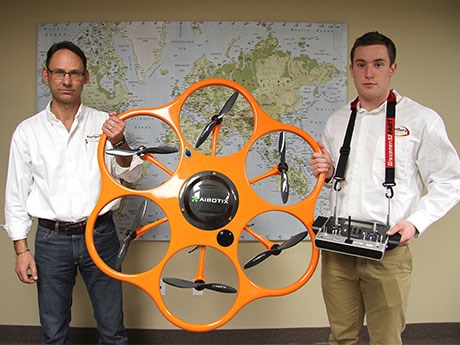
The Aibot X6 V2 is 3.4-feet wide and 1.5-feet high. It is made out of carbon fibre reinforced polymer and weighs just 3,400 grams. It has a maximum speed of 24.8 miles per hour and a climb rate of 17.9 miles per hour. Under ideal conditions, it can fly as high as 3,280 feet above ground level and climb at a rate of 26 feet per second.
It features a lithium-polymer battery capable of 30 minutes of flight time and can operate in temperature ranges of -4 to 104 degrees Fahrenheit. It features a GPS sensor, gyroscope, accelerometer, barometer and ultrasonic sensors. It also has a universal camera mount and is capable of carrying a three kilogram payload. Digital SLR cameras, thermograph and video cameras are just a few types of imaging equipment that can be mounted.
The Aibot X6 V2 is ready to use out of the box thanks to a fully automatic calibration process, which allows the user to push one button to start the motors and begin flying. It has six covered rotors, so propellers will not break if accidental contact is made with a structure.
The unit can be controlled through a standard remote control device or through a tablet PC.
The Aibot X6 has numerous advantages over fixed-wing UAVs, including horizontal and vertical take off capability.
It can take off and land almost anywhere and has a camera mount with automatic pitch and roll compensation for flexible camera angle.
The Aibot X6 also has advantages over other rotary UAVs, including protected propellers, higher payload capacity, sixengine power, which allows the vehicle to continue flying if one engine fails, fully automatic take-off and landings, flight plan executions, Leica Geosystems sensor systems, data management software and worldwide sales and service through local distributors.
“The vehicle saves time when it comes to surveying,” Warkentin said. “It can do surveying in a fraction of the time at less cost. It is practical and can even be transported in the trunk of a car. There has already been a huge response to it. We have a lineup of people asking for pricing and wanting one.”
With the software included, the Aibot X6 becomes a dream machine for processing information for a variety of industries. It takes aerial photographs for land surveying, mine stockpiles, 3D models of buildings or surveyed land masses, and thermograph images for the maintenance of solar systems, to name a few applications.
“It can fly along a conveyor at a mine and inspect hot spots for faulty components,” Warkentin said. “There are many uses for it. Some of the areas we have touched are in mining and geology, using it at mine sites for volume calculations and tailings ponds surveys, agriculture, forestry, police departments … there is interest from all kinds of industries.
Francis Nepveu, who looks after technical support and training for NSS, has undergone extensive training on the Aibot X6 since February. Learning to fly the vehicle is easy and always leaves Nepveu wanting more flight time.
“The first time I operated it, I had a big smile on my face the whole time,” Nepveu said. “It was easy to learn to fly. Remote control helicopter toys are more complicated to operate. If you take your hands off the remote, it stays where it is. I had two days training and I was comfortable flying it on the first day.”
A unit with software and training costs between $80,000 to $100,000 depending on imaging equipment. “Our job at NSS is to look at the technology out there, weed out the useful ones and help our clients be more productive,” Warkentin said. “The Aibot X6 will do that. The whole industry is going to change.”


