 A new high-resolution resistivity and induced polarization technology developed in Germany for geotechnical applications is gaining acceptance in Ontario’s mining industry.
Marketed by Caracle Creek International Consulting (CCIC) as EarthProbe, the technology was introduced to the mining industry by physics professor Bernd Milkereit and post doc Wei Qian at the University of Toronto through trials in Sudbury between 2006 and 2009.CCIC got into the picture by showcasing the technology at the PDAC in March 2010.
“What’s different about it is that it came out of a geotechnical application where they’re not really interested in looking very deep,” said CCIC general manager Rob Gordon. “They’re mostly interested in looking at the top 20 metres, but what they’re after is high-precision detail.
“With EarthProbe, not only are we collecting data every five metres, but we’re not limited to the array length we can lay out on surface. Currently, we’re working with array lengths of up to 900 metres.”
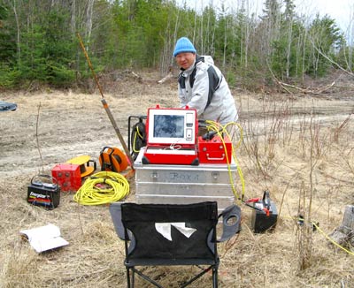
The line is laid out in advance and a system controller pushes current into the ground at each electrode station in succession.
“It’s a very smart system,” said Gordon.
“In a traditional survey, you have a team of people who will move up all the stakes, cables and the receiver, measure it and move it up again. In our case, the labour intensive work starts at the beginning of the day laying out the cable on the ground.
With the 900-metre array, EarthProbe is able to provide resistivity and chargeability readings as deep as 250 metres.
“The other thing that’s unique about this technology is that you can also use it for borehole surveys,” said Gordon.
CCIC is currently using a 100-metre cable with nodes every four metres, as well as a 400-metre cable with nodes every 16 metres.
“We drop the cable down the hole and the receiver unit at the top will carry out an IP survey, imaging off the hole to about one-third of the length of the cable.”
CCIC is also doing borehole-to-borehole surveys to assess the continuity of mineralized zones.
So far, surveys have been completed in Sudbury for Vale and Xstrata Nickel, as well as in Red Lake, Dryden and Bathurst, New Brunswick.
“One of our earlier clients has already asked us to come back because they’re in the middle of a drill program and they want real-time follow-up with EarthProbe surveys” to provide off-hole data and help them zero in on mineralized zones they may have missed.
“Gold veins are often very small and traditional IP just gives you a vague picture of what’s down there,” said Gordon. “What we’re trying to do is get a much more comprehensive, detailed picture. Our process is not designed to cover giant blocks of ground, but to try to focus in on particular areas that people might be interested in.”
Drilling holes is expensive and, if you miss, you can waste a lot of money, said Gordon. “So, it’s very useful to be able to put down a probe and sense whether you’re near something. We can do five holes a day very efficiently and help to generate some really viable alternative targets that people have missed.”
EarthProbe borehole surveys have the potential to go much deeper, but a 2,000-metre cable would cost somewhere in the neighbourhood of $150,000 and require specialized equipment to support the weight. That kind of commitment to geophysics is common in the oil and gas industry, but not in the mining industry - at least not to date, noted Gordon.
Suppliers to the oil and gas industry have huge trucks with giant reels of cable that go down 2,000 to 3,000 metres, he said. “These trucks are worth more than our company. The levels of scale are just so vastly different.”
Greater use of geophysical surveys in the mining industry could help increase the pace of discoveries, said Gordon.
“If you polled all of the junior mining companies in downtown Toronto, you’d find that most of them don’t even know what physical rock properties are.”
Exploration companies are often in such a hurry to drill, get the results and report them that they don’t take the time to do routine measurements of rock properties using borehole geophysics, said Gordon.
“If the geologist who looks at the colour, texture and structure of the rocks can incorporate information about the chemistry and physics of the rocks, we’ll be much better off.”
More precise surveys made possible by EarthProbe are bound win more respect for geophysics, said Gordon. Until now, a geologist following up on a geophysical survey using conventional technology would drill a “red blob,” come up empty, and lose faith in the technology.
There have been no breakthrough discoveries to date attributed to EarthProbe surveys, but Natural Resources Canada has agreed to fund a research project using the technology in known mineralized zones to demonstrate how the system works and how it can provide meaningful information to geologists.
CCIC and its partner currently have a formal arrangement with the developer of the technology in Germany to provide the service to the mining industry in North America. The company may also pursue worldwide rights to the technology, depending on the extent to which EarthProbe is embraced.


