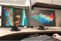
 Driving innovation is the goal for Sudbury’s Mining Innovation, Rehabilitation and Applied Research Corporation’s (MIRARCO) new open source visualization and data integration software package called ParaViewGeo. Recently launched, it is a visualization platform for geological 3-D modelling and other complex datasets or programs.
Andrew Dasys, MIRARCO’s vice president and brainchild of the software product, sees it as a way to spur on creativity within the scientific community.
"We want ParaViewGeo to develop the same type of community Apache developed and to drive innovation the way Apache, Linux, and Open Office (all open source software) have within the mainstream," Dasys said, explaining the concept of many eyes. As more people use the software and a community develops, new ideas are brought to the table, possibly improving and expanding upon the original software ideas.
The open source software, available at no cost, works in several ways. It can take data from existing commercial software such as mine infrastructure, drill holes, assays, lithologies, orebody block models, plan and cross-section diagrams, surface geology, faults, dykes, gravity and magnetic surveys, aerial photos, and seismic events, and integrate the different file formats into one visual presentation.
"One of the core reasons for ParaViewGeo’s existence is to integrate all of that data and make compelling presentations that give exploration staff and mining engineers more context for the data they are looking at," said Chris Cameron, one of the software developers who worked on the application.
ParaViewGeo also allows users to go in and make modifications as required in order to display "their idea," offering complete control to the programming-savvy user. Dasys describes it as "promoting innovation" and says he would like to see it introduced in universities.
Dasys, who is a visual learner, believes the quickest way to understand simulation, particularly with time and space, is through visualization. ParaViewGeo provides the framework to show information in a way that can be understood.
An example of that is MIRARCO’s new commercial software called the Schedule Optimization Tool (SOT). The SOT uses genetic algorithms to help mine designers produce better scheduling options. The software can in a very short amount of time generate a large number of possible development and extraction schedules. It then evaluates the financials associated with of each schedule. The data is then sent to ParaViewGeo to help the designers determine which schedules have the highest value and lowest risk.
ParaViewGeo is "built on top of" ParaView, U.S. Government-funded software developed by Kitware in upstate New York that has created a visualization library. As a software package, ParaView has a multiprocessing capability (up to 256 processors), making it a high performance program. The average PC computer has one or two processors.
"It’s a huge amount of data and is pretty complex," Dasys said. "ParaView has that parallel capacity to deal with the future and accommodate even larger databases than we currently have."
Kitware has allowed MIRARCO, a not-for-profit research and development centre, to create this extension of ParaView by adding modules geared to exploration and mining. Some of the basic capabilities in the ParaView framework include:
mutiple cameras on the same data,which allows one to look at several angles at once
the ability to filter (e.g. look at specific drill holes with specific values) and transform the data (e.g. calculate how many times an object intersects a certain area in space or time)
the ability to animate timed data. An occurrence over time can be animated and shown and controlled like a video
state files let you save the "state" of your data into a file, and
scalability for larger datasets. ParaViewGeo can handle millions of "blocks" of data using only one processor. More processors can increase the scale of the model to tens or hundreds of million of blocks.
ParaViewGeo was developed by 10 individuals over two-and-a-half years with financial support from the Northern Ontario Heritage Fund. During its development, the programmers submitted their written text to a repository. Like most open source software programs, all changes to the code are stored and tracked in a revision-control system. This makes it easier to look at bugs, or see what has changed in the software over time.
"Any major software will have that kind of tracking," Dasys said. "It is a requirement of software development."
The program, available for downloading at paraviewgeo.mirarco.org, requires 40 megabytes of disk space. A subdirectory of Python code, a programming language, is provided to help manoeuvre within the program.
The benefit of ParaViewGeo is that it will give users context to their operations in a 3-D display that they would not otherwise have produced with 2-D drawings or other single-use proprietary software. MIRARCO’s Virtual Reality facility allows groups to look at their information to promote questions about the data and assist in determining mine development plans.
Like any new software, there is a bit of a learning curve, but most of the feedback has been positive regarding its ease of use. Both Cameron and Dasys agree that anyone can use ParaViewGeo with an introductory lesson. A free introductory wiki at paraviewgeo.mirarco.org is available which includes a training video.


