Clickmox Solutions, a Sudbury-based company specializing in 3D LiDAR scanning, robotics, geotechnical monitoring and point cloud data processing, has concluded an agreement with a U.S. company for the sale of its drone and vehicle-based scanning systems.
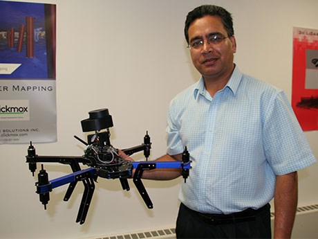
The Clickmox drone-based system, called the MineFly, will be used to measure methane levels in coal mines, while the vehicle-based scanner, called the R-SCAN3D, will be used to confirm ground stability.
Both systems employ Simultaneous Localization and Mapping (SLAM) technology, which combines 2D laser scan data with laser sensor position data to generate accurate 3D point clouds.
“In the U.S., there is a regulation requiring coal mines to measure the level of methane after every cut at seven different locations within 20 minutes, but it’s a challenge because there isn’t any technology out there that can do it,” said Clickmox president Syed Naeem Ahmed. “You can’t send people in there because of the potential danger. Using the drone, they can measure the level of methane and correlate it with the positioning information because of the 3-D mapping system.”
The deployment of the MineFly is on hold pending MSHA approval, but Ahmed expects orders for 40 to 50 vehicle-based scanners within the next few months because it’s fully enclosed and easier to approve.
Clickmox’s only competition is from a U.K.-based company, which has a hand-held scanning system, “but it’s not real-time,” said Ahmed. “You do the scan, upload the data to their server and pay for the data processing. Then you get the point cloud. If there’s a problem with the scan, you have to go back and redo it. That’s costly and time consuming. Our system gives the user the ability to see the map in real-time as it’s being produced and we don’t charge for data processing. If there’s a problem with the scan, you know right away. You just stop and restart it.”
Clickmox has also received interest from Vale and the Glencore operations in Sudbury to use the MineFly for precisely determining the location of ore pass blockages, but once again, deployment may first require safety certification because of its use of radio signals.
Clickmox will be displaying the MineFly and the R-SCAN3D at the PDAC, March 6 to 9.


