MyMaps features a spatial display with links to public databases
MyMaps, a new web-based mapping tool, may not help exploration companies make their next ore discovery, but it will bring together all the information about their properties in one easily accessible location.
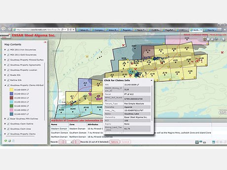
Developed and marketed by Caracle Creek International Consulting (CCIC), MyMaps “allows companies and individuals to compile any attribute information that can possibly relate to their lands,” said software architect and lands management specialist Tania Poehlman.
The information, which can be proprietary data or pulled from public sources such as Ontario’s Ministry of Northern Development and Mines, is accessible from a zoomable property map, with each level revealing clickable icons triggering pop-up boxes with links to reports, agreements and other documents.
“It might be a map of your property showing all the tenure boundaries, whether that’s dispositions or patents and leases or unpatented mining claims,” said Poehlman. “Within there, it can show geology, so it can be useful not only for a lands manager, but also for a geologist. We can incorporate any assay results, as well as historical work reports that can come from public databases or from proprietary information.”
The application sits on a server in a hosted environment and is accessed via secure login from any computer or mobile device with an Internet connection.
One of the things that really sets MyMaps apart, aside from the advantage of the spatial display, is the ability to import information about obligations such as expenditure requirements through scheduled updates, said Poehlman. Email alerts can also be set up to proactively inform lands managers of impending deadlines.
“MyMaps also lends itself really well to being a document repository. Companies are notoriously bad at maintaining a document library of the executed versions of their documents such as signed agreements or other obligations. They tend to hide on people’s laptops or storage boxes and they lose track of where they are. I hear it time and time again. With MyMaps, once we load up the pdfs, they don’t leave. They’re always accessible.”
According to Poehlman, who has years of experience in lands management and IT, “there’s nothing like MyMaps on the market. There are a lot of lands management software packages, but none of them do automatic updates with public databases and very few of them have any kind of spatial display.”
It’s also great for geologists because “you can incorporate historical results – either your own or whatever is out there - that has been done by other companies or government research. It can be a pdf of a cross section, for example, and because it’s arranged spatially on the screen in front of you, you’re not spending weeks trying to sort through a variety of sources trying to find reports and piecing it all together. It’s all in front of you.”
MyMaps has also been designed to help prospectors and exploration companies process applications for plans and permits under Ontario’s recently amended Mining Act regulations.
“One of the biggest sources of grief is being able to produce all the elements on a map that are required as part of the application process,” said Poehlman. “With MyMaps, all you have to do is click on print for that project and the appropriate map prints out.”
Using Ontario’s CLAIMaps application, applicants lose a lot of the required attribute information when they print at a certain scale, she noted.
“The other thing that’s confusing for people is that information about where you’re going to be performing the work has to be down to the unit level, but the Ministry doesn’t define that anywhere, so it’s really throwing people for a bit of a loop. With MyMaps, one click of the mouse superimposes the appropriate grid over your map, allowing you to just point and click on the cells where you’re going to be doing the work.”
Clients pay CCIC an hourly rate for setup, which entails compiling the data and publishing it to the website, creating links and scheduling updates, following which clients pay a monthly subscription fee.
“We can set up a client in as little as a day or it can take months, depending on complexity and how much information they want,” said Poehlman. “If the property is made up entirely of unpatented mining claims and all the information is accessible on a government database, then it’s very quick.
“Where it gets longer is if there is a need for us to go through agreements, interpret them and pull out the obligations.”
MyMaps builds on an earlier software release designed to alert mining claim holders of pending expiry dates, “but this takes it to the next level,” said Poehlman.
CCIC is a geophysical and geological consulting company with offices in Toronto, Sudbury, Vancouver, South Africa and the Dominican Republic.


.jpg;w=120;h=80;mode=crop)