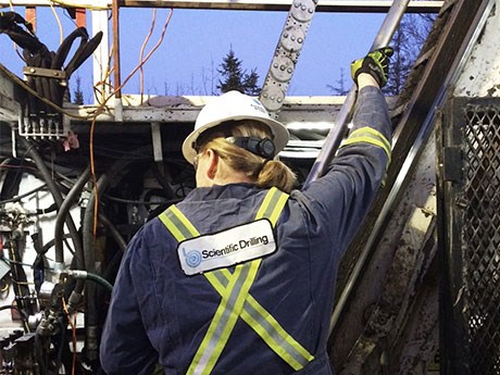
Gyro surveying service provides precise geospatial information for diamond drilling holes
Scientific Drilling International (SDI) has established an office in North Bay to provide gyro-surveying services to mining companies in Quebec and Ontario following a decision by oil services giant Haliburton to abandon the business.
Gyro surveying services in Ontario and Quebec had been provided by Haliburton since the late 90s when it acquired Sperry-Sun.
“Haliburton inherited this little office in North Bay and while they were making money and doing well, they left it alone, but over time, they lost interest,” said senior gyro surveyor Tony Plackitt, who worked for Haliburton and now serves as SDI’s lead local representative.
Haliburton abandoned the manufacturing of gyros when it acquired Sperry-Sun, requiring Plackitt and fellow gyro surveyor Aaron Crosby to use rented SDI instruments for their surveys. So except for the logos on their jackets, not much has changed for customers – with one important exception: the software used for processing the data collected by the gyros.
The two companies – Haliburton and SDI – are competitors in the oil and gas services business and were guarded about sharing their intellectual property.
“Haliburton in North Bay had to use older software because around 2006, we stopped getting upgrades,” said Plackitt. “As soon as we became SDI, all that opened up to us. We jumped 15 versions in a single bound. With the new software, we’re able to sample everything – whether it’s a 200-metre hole or a 2,800-metre hole – at one-metre intervals. We could do it before but we’d be forever processing the data. Now, we can handle the volume of data as quickly as we could handle data from 10-metre intervals. It tightened up our surveys by 50 per cent, so they’re both faster and more accurate.
“At Haliburton, we said we guaranteed we’d be within two metres. Now, we’re saying we can get that under one metre, doubling our accuracy.”
Having precise geospatial information for diamond drill holes is important for defining an orebody and calculating ore reserves, but critical for an exploration or mining company concerned about drill holes deviating beyond its property boundaries into another company’s ground.
The SDI North Bay office performs gyro surveys from Rouyn-Noranda in Quebec to Red Lake in northwestern Ontario.
Many of the holes surveyed are going to greater depths, said Plackitt.
Glencore, for example, is drilling 2,800-metre holes at its Nickel Rim Deep project, Vale has drilled to a depth of 3,200 metres at its Victor Mine, and at its Craig Mine, Glencore has two drills at the 4,900-level drilling 1,400 to 1,600-metre holes.
Plackitt was hoping to see the industry rebound this year, but initial indications of a more buoyant market fizzled.
“Junior mining companies were starting to see some more investment at the beginning of the year, but it died off,” he said. “We’re now starting to see some signs of climbing out of the rut, but not quickly. The projection for 2016, however, is much better.”


