The Northern Road Link, the middle stretch of the proposed Ring of Fire road network, will undergo a federal environmental assessment, the Impact Assessment Agency of Canada (IACC) announced last week.
The determination by IAAC that an assessment is required was based on the possibility that the road could cause negative impacts to fish, birds and the socio-economic well-being of the Indigenous people in the area. Feedback on the project came forth from the public, Indigenous groups, various federal agencies and others, IACC said.
IAAC officials could not immediately provide any date on when an assessment would begin, nor provided any context on how an assessment will mesh with Ottawa’s recent announcement to reboot of its Regional Assessment process on the Ring of Fire area. Discussions about the terms of reference of this wider assessment has only just started.
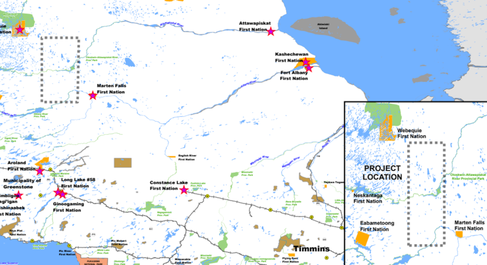
The proponents are Webequie and Marten Falls, two remote communities without permanent road access.
The road would help connect the mineral deposits in the McFaulds Lake area of the James Bay region to the provincial highway system. It would also facilitate the movement of goods, services, resources and people into the region for the first time.
The project will be 117 kilometres to 164 kilometres – depending on the final route chosen during the assessment - with a 60-metre cleared area and a 100-metre right of way. The south end of the road would be 150 kilometres north of the Municipality of Greenstone.
The Northern Road Link is bookended by the proposed Webequie Supply Road to the north and the proposed Marten Falls Community Access Road to the south.
A project description filed to the federal government said aggregate for the road would be extracted from nearby pits and quarries with crushing plants set up along the way. Some of these pits will remain open after road construction is finished to allow for general road maintenance.
There will be temporary construction camps, accommodating up to 200 people, and laydown areas about every 20 kilometres along the route to support construction activities. Some larger camps will be located next to major river crossings.
In the project’s comment section on the IAAC registry, Fort Albany Chief Elizabeth Kataquapit had “serious concerns.”
Fort Albany is a Cree community located on the James Bay, about 250 kilometres from the Ring of Fire mineral deposits. The community said this proposed road is on their traditional land as well as the entire Ring of Fire mineral belt.
In a March letter to IAAC, Kataquapit is concerned that the project’s potential “downstream and down-muskeg effects” might interfere with the community’s harvesting, cultural, governance and stewardship rights on the land.
The leadership said there’s “insufficient information” on how project activities could impact the Albany River watershed.
In the letter, Kataquapit said mining development in a “highly ecologically significant” area like the Ring of Fire could be “devastating” to the ecosystem, wildlife and contribute to climate change. A road would allow for increased access by forestry, oil and gas interests, and more commercial and recreational hunting and fishing, she wrote.


