The days of traditional staking rushes in Ontario will fade into history once Bill 173 passes this fall. For some, it is a good thing, but for others, it represents more than the disappearance of a tradition.
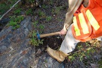
The controversial bill is a provincial government initiative to implement a host of legislative changes to Ontario’s Mining Act. One of the changes impacts how land claims are staked. Currently, claims are staked by prospectors or anyone holding a prospector’s license. They must physically go on the land and erect posts in a clockwise fashion, marking off the claim. The smallest claim is a single unit consisting of a 16-hectare square. The largest claim can be 16 units or 256 hectares. The claim details and completion time must be sent to the mining lands consultant or the provincial recording office in Sudbury within 31 days. If all the procedures are carried out properly, the person or company with the earliest time posted on the claim will acquire it. Exploration must occur on the parcel of land by the second year to keep the claim active.
If Bill 173 is passed, all land claims will eventually be performed online by computer instead of on the ground.
Garry Clark, executive director of the Ontario Prospector’s Association (OPA), said map staking is a lightning bolt for a lot of people. “There are a lot of letters bouncing back and forth from different prospecting associations across the province as well as from prospectors.”
Past OPA membership surveys on map staking show the response was evenly divided: one-third against it, one-third for it, and one-third didn’t care as long as they could stake land.
Doug Parker, a 20-year veteran prospector who resides in Thunder Bay, said it’s not so much that map staking is being introduced as ground staking is being phased out. “There’s always been a form of map staking in Ontario called the Exploratory License of Occupation,” a rarely-used provision of the present Act that requires annual cash payments to the Crown. It was put in place for companies interested in staking large tracts of land, said Clark.
Impact on the land
From the government’s perspective, online map staking is easier, has less impact on the land, and allows anybody with a prospector’s license to stake from anywhere in the world. It is a way to modernize claim staking, take advantage of technology and manage land tenure more easily in Ontario, according to Marc Leroux, senior manager of information and marketing services at the Ministry of Northern Development, Mines and Forestry (MNDMF).
“Map staking eliminates the first point of contact - being feet on the ground,” he said.
In the past, ground staking practices have led to some conflicts with private land owners and Aboriginal communities. Under the new system, landowners will receive notification prior to exploration.
“The first point of contact will be a knock on the door or a letter in the mail,” Leroux said. “It won’t be some person walking on the ground erecting posts, which has been an issue, especially in southern Ontario.”
Leroux said consultations on map staking have been going on for at least 10 years, but there has been a lot of resistance, which is one of the reasons Ontario has been slow to come on board.
There are concerns about how it will be regulated should a company with deep pockets come in and stake large tracts of land.
Parker said mining companies like it because electronic map staking is an easy way to obtain mineral rights at little expense.
“You don’t have to hire people from a northern community to go out on the land and stake, or hire planes to go to an area,” he said. “Those expenses are eliminated. It gives them security of tenure and they don’t have to worry about whether or not a claim was staked properly.”
It is also a loss of income for the commercial claim staker and prospector. For those wanting to get involved in prospecting, it marks a loss of an entry point into the industry, especially for those in First Nation communities in the Far North, said Clark. Also, when there is a staking rush, many people are on the land. This results in the land being broken up into many landholdings and more money being spent on exploration.
Parker, who has prospected all over Canada for others and himself, said not only will the prospector be disadvantaged, but it will also result in a loss of business for communities where staking may occur.
“They won’t be using the commercial resorts, hiring float planes, staying at motels, buying meals and supplies, etc.,” he said.
First Nations
First Nation communities that are just starting to get into prospecting and exploration work are also being disadvantaged, he added.
Other concerns are that mining companies will come in and stake large tracts of land, in some cases for speculative reasons.
“They are hoping someone on the next property will find something,” Parker said. “That is often why a lot of staking is done near former head frames or existing mining operations because they can promote to their investors that they are in the right place. Many of the juniors simply do assessment work to satisfy groundwork requirements and hold the claims longer.
On the flip side, prospectors who may not have had the finances to stake claims in inaccessible areas now have the opportunity to do so.
The bill has gone to standing committee and third reading is expected in the fall. Once passed, the regulations will be written. The process of developing an electronic map staking system is estimated to take between three and five years. Paper map staking will be implemented in southern Ontario first.
“The problem is that we have over 360,000 active claims in Ontario,” said Leroux. “It is a very complicated fabric, and some of the claims have been around for a long time.”
Ontario plans to borrow best practices from the other provinces in developing online staking software.
Quebec
Quebec was the first province to cut its teeth on an electronic system in 2000, although Newfoundland had been practicing a paper map staking system in Labrador since August 1983, and for the entire province since September 1995. Newfoundland converted to an online format in February 2005.
Jim Hinchey, manager of mineral rights for the Mineral Lands Division of Newfoundland’s Department of Natural Resources, said they switched to a map staking system to make it easier to acquire claims. Although it took four years to develop the online technology, Hinchey said the transition was short because they had the paper map staking system already in place.
“We didn’t have some of the issues of legacy claims like Ontario has,” he said. Since they moved to the electronic system, approximately 230,000 claims have been staked.
British Columbia implemented map staking in January 2005 with a two and a half year transition, according to Jake Jacobs, public affairs officer for B.C.’s Ministry of Energy, Mines and Petroleum Resources. He said the province maintains open communications with its clients and resolves problems quickly.
“Despite the number of challenges associated with this kind of application, our titles online registry has not yet failed,” he said. “Industry tells us that B.C. has the best registry in the world.”
Other provinces coming online are Nova Scotia, New Brunswick and Manitoba.
Ontario’s MNDMF Mining Land Section senior manager Roy Denomme said the ministry has not formalized a strategy on how to handle legacy claims, but he said a standard must be developed and incentives offered for claim holders to go out and find the GPS co-ordinates that will accurately define where the claims are located.
“There are already things on our map that we know are plotted very accurately like survey plans. We’ll be using some of that to help guide us.”
Ontario’s annual 25 per cent turnover of mining claims will help move things along during the implementation phase over the next couple of years, Denomme said. “It is a very fair system. It all depends on how well you set it up. In B.C. and Newfoundland, it was a success story.”
Most of the provinces that are using the system started out with some resistance to the idea, Denomme said, but after implementation, the responses were positive.
“Ultimately, it is boot and hammer that finds stuff,” said Clark. “If there’s outcrop, somebody has to go out there and break the rock off, look at it, throw it in a bag and see if there’s anything in it.”


