By Colleen Kleven
A large seismic reflection survey, part of Metal Earth’s year one research, is now complete, and already this massive, geoscience initiative has started to shake things up.
Led by Laurentian University’s Mineral Exploration Research Centre (MERC), an internationally recognized industry-funded hub for exploration science and education within the Harquail School of Earth Sciences (HSES), Metal Earth is a $104 million, seven-year applied R&D program supported by a $49.2 million grant from the Canada First Research Excellence Fund – the largest geoscience grant in Canada’s history.
This collaborative research initiative has 25 Canadian and international partners from academia, government and industry focused on revolutionizing global understanding of the geological processes responsible for base and precious metal endowment.
At a time when mineral exploration discovery costs are increasing while the quality of discoveries is decreasing, this information is crucial for development of better targeting tools and the discovery of new mines world-wide.
Seismic reflection data collection and integration phase
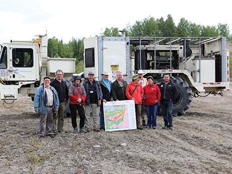
Year one included transect-scale data collection with seismic reflection surveys in the Abitibi and Wabigoon greenstone belts, and work in the Cobalt and Sudbury areas. SAExploration, a seismic contractor in collaboration with MERC faculty, completed seismic lines over 14 different transects ranging from 40 kilometres to 140 kilometres in length, for a total of 1,069 line kilometres. In June 2017, teams of student researchers, supervised by MERC and HSES faculty researchers, conducted initial geologic field work along five Abitibi transects in Quebec and Ontario.
Vibroseis trucks with two-tonne pressure plates shook the ground so that seismic reflection signals in low and high frequencies, similar to sonar or ultrasound, could be recorded using geophones spaced along the route. Each line was geophysically mapped in lower resolution R1 mode to a depth of 40 kilometres. Higher resolution R2 mode was completed in areas of geologic interest and complexity to provide details of upper crustal features. A third, experimental R3 mode, known as full waveform inversion, with vibroseis trucks supplemented by dynamite blasting, was used to image steep subvertical structures that are a challenge for traditional reflection seismic surveys in R1 and R2 modes.
Not only did the $5.5 million contract come in on time and on budget, but it also marked the first time full waveform inversion methods have been used to map crystalline rocks.
“Full waveform inversion has never been attempted in crystalline rock but it has the potential to image steep structures that dominate ancient crystalline terrains and are a challenge for standard reflection surveys. This technique could revolutionize how we use seismic methods to explore for metals in ancient terrains,” explained Harold Gibson, director of Metal Earth. “The different seismic reflection modes we used were designed to overlap along transects so that, for the first time, we have data from the different modes to compare and analyze. It will be a benchmark in our understanding of how to interpret full waveform seismic data.”
Field research activities focused on gravity and magnetic surveys will continue into 2018, with magnetotelluric and audio-frequency magnetotelluric surveys starting in April along transects previously covered by the seismic reflection survey.
Transect geological data will be collected until 2020 to ensure uniform data coverage between transects and to solve
unresolved geologic problems over specific transects.
“The seamless integration of this newly acquired geological and geophysical data with historical data is another area where Metal Earth is breaking new ground. Integration, interrogation and visualization of diverse geoscience data will, for the first time, provide crust to mantle images at the ore system that can be compared to establish the differences between endowed and less-endowed greenstone belts and better identify the areas with higher mineral potential,” said Doug Tinkham, director, HSES. “This has global significance, with the ultimate result being exploration mapping tools to help increase exploration success.”
The first processed and interpreted seismic images will be available for the Abitibi transects in 2018 and for Wabigoon, Cobalt and Sudbury in 2019.
World-class research and innovation
Craton-scale research, another area of focus, was initiated in 2017 and will continue until 2023 with geochronological and geophysical compilation, data collection and geological mapping of crustal-scale pathways to better understand greenstone belt architecture, terrane assembly and ore district formation in selected areas of the Superior Craton, the core of the Canadian Shield.
Metal Earth will begin thematic research from craton to deposit scales in 2018 that continues to 2023, with research aimed at addressing specific processes or questions related to understanding the processes responsible for differential metal endowment and exploration.
Additionally, data analytics research activities will begin in 2018 and extend to 2023 to develop new integration, analysis and interpretive tools to predict metal endowment and guide exploration.
The mining industry and the mining supply and service sector will have unprecedented opportunities. Development of commercial exploration targeting tools including modeling algorithms and software, new transformative technologies, and techniques to integrate, interpret and visualize complex, diverse, geoscience data is anticipated to start in 2019.
Metal Earth has enhanced capacity of Sudbury’s Laurentian University and HSES to support this world-class research by providing the funding to hire five tenured and tenure-track new faculty including Dr. Leonardo Feltrin, Associate Professor, Earth Systems Modelling and Data Analytics; Dr. Mostafa Naghizadeh, Assistant Professor, Exploration Geophysics Seismic Methods; Dr. Stéphane Perrouty, Assistant Professor, Precambrian Geology; and Dr. Ross Sherlock, Director of MERC and incoming Director of Metal Earth. Lucie Mathieu was hired at Metal Earth partner institute Université du Québec à Chicoutimi; and to complement increased capacity, Dr. Jeremy Richards, Tier 1 Canada Research Chair in Metallogeny, joined HSES in 2017.
Metal Earth funded acquisition of a new multi-collector laser ablation ICP-MS for advanced isotope and metal analysis, and supports six research associates. Over the seven years of Metal Earth, a total of 22 postdoctoral fellows, 20 PhD, 70 MSc and PhD students, and 105 BSc students will be mentored and trained at HSES and MERC and other partner institutions through field and applied research built upon the collection of this initial seismic reflection data.
“Metal Earth’s year one seismic survey will become a layer of data to allow us to interpret the subsurface geological architecture of these belts. This provides a much broader understanding of the geological framework of these highly prospective areas,” said Ross Sherlock, MERC director and chair in exploration targeting, HSES. “Providing framework geoscience will allow industry to understand greenstone belts with a higher degree of resolution than has ever been the case in the past. Metal Earth’s ultimate objective is the successful development of predictive models of mineral potential that de-risk exploration programs and allow a much higher degree of confidence when making land use planning decisions.”
Metal Earth welcomes industry involvement on the ground floor. Stay informed about research activities and findings through MERC newsletters, Metal Earth short courses or by becoming a MERC member. www.merc.laurentian.ca


